Duinen Ameland: verschil tussen versies
Naar navigatie springen
Naar zoeken springen
| Regel 10: | Regel 10: | ||
| gebiedsnummer = 5 | | gebiedsnummer = 5 | ||
| richtlijn = Habitatrichtlijn + Vogelrichtlijn | | richtlijn = Habitatrichtlijn + Vogelrichtlijn | ||
| − | | sitecode = NL3009005 | + | | sitecode = [https://natura2000.eea.europa.eu/Natura2000/SDF.aspx?site=NL3009005 NL3009005] |
| km2 = 20,55 km² | | km2 = 20,55 km² | ||
| dichtbij = | | dichtbij = | ||
Versie van 20 mei 2024 14:58
| Duinen Ameland | |
| Land | |
| Classificatie | Duinen |
| Gebiedsnummer | 5 |
| Richtlijn | Habitatrichtlijn + Vogelrichtlijn |
| Sitecode | NL3009005 |
| Km2 | 20,55 km² |
| Locatie | Ameland, |
| Gesticht | 25 februari 2009 |
| Beheer | Domeinen, Staatsbosbeheer, Rijkswaterstaat, It Fryske Gea, particulieren |
| Website | Duinen Ameland (Natura 2000) |

| |
| Duinafslag 2007 | |

| |
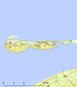
| Kaart Duingebied Ameland | |
| Portaal Lijst Natura 2000 | |
Duinen Ameland is een natura 2000 gebied op het eiland Ameland, provincie Friesland. Het gebied wordt beheerd door de Domeinen, Staatsbosbeheer, Rijkswaterstaat, It Fryske Gea, en door particulieren.