Lijst van gemeenten in Zeeland: verschil tussen versies
Naar navigatie springen
Naar zoeken springen
k (Robotgeholpen doorverwijzing: Sluis - Koppeling(en) gewijzigd naar Sluis (Zeeland)) |
|||
| (19 tussenliggende versies door 3 gebruikers niet weergegeven) | |||
| Regel 1: | Regel 1: | ||
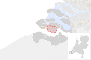
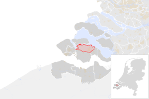
| + | Hieronder staat een lijst met alle 13 huidige gemeenten in de [[Nederland]]se provincie [[Zeeland (provincie)|Zeeland]]. Hierbij staan de naam, de inwoners en een plaatje met de ligging vermeld. De gegevens zijn voor het laatst in 2016 bijgewerkt. |
||
| − | * [[Borsele]] |
||
| + | {| class="wikitable" |
||
| − | * [[Goes]] |
||
| + | ! # |
||
| − | * [[Hulst (Nederland)|Hulst]] |
||
| + | ! Naam |
||
| − | * [[Kappele]] |
||
| + | ! Inwoners |
||
| − | * [[Middelburg]] |
||
| + | ! Oppervlakte |
||
| − | * [[Noord-Beveland]] |
||
| + | ! Hoofdplaats |
||
| − | * [[Riemerswaal]] |
||
| + | ! Kaart |
||
| − | * [[Schouwen-Duiveland]] |
||
| + | |- |
||
| − | * [[Sluis (Zeeland)|Sluis]] |
||
| + | | 1 |
||
| − | * [[Terneuzen]] |
||
| + | | [[Borsele (gemeente)|Borsele]] |
||
| − | * [[Tholen]] |
||
| + | | 22.636 |
||
| − | * [[Veere]] |
||
| + | | 141,72 km² |
||
| − | * [[Vlissingen]] |
||
| + | | [[Heinkenszand]] |
||
| + | | [[Bestand:NL_-_locator_map_municipality_code_GM0654_(2016).png|300px]] |
||
| + | |- |
||
| + | | 2 |
||
| + | | [[Goes]] |
||
| + | | 37.211 |
||
| + | | 92,68 km² |
||
| + | | [[Goes]] |
||
| + | | [[Bestand:NL_-_locator_map_municipality_code_GM0664_(2016).png|300px]] |
||
| + | |- |
||
| + | | 3 |
||
| + | | [[Hulst (stad)|Hulst]] |
||
| + | | 27.382 |
||
| + | | 201,44 km² |
||
| + | | [[Hulst (stad)|Hulst]] |
||
| + | | [[Bestand:NL_-_locator_map_municipality_code_GM0677_(2016).png|300px]] |
||
| + | |- |
||
| + | | 4 |
||
| + | | [[Kapelle (Zeeland)|Kapelle]] |
||
| + | | 12.653 |
||
| + | | 37,13 km² |
||
| + | | [[Kapelle (Zeeland)|Kapelle]] |
||
| + | | [[Bestand:NL_-_locator_map_municipality_code_GM0678_(2016).png|300px]] |
||
| + | |- |
||
| + | | 5 |
||
| + | | [[Middelburg (Zeeland)|Middelburg]] |
||
| + | | 47.939 |
||
| + | | 48,54 km² |
||
| + | | [[Middelburg (Zeeland)|Middelburg]] |
||
| + | | [[Bestand:NL_-_locator_map_municipality_code_GM0687_(2016).png|300px]] |
||
| + | |- |
||
| + | | 6 |
||
| + | | [[Noord-Beveland]] |
||
| + | | 7.435 |
||
| + | | 85,82 km² |
||
| + | | [[Wissenkerke]] |
||
| + | | [[Bestand:NL_-_locator_map_municipality_code_GM1695_(2016).png|300px]] |
||
| + | |- |
||
| + | | 7 |
||
| + | | [[Reimerswaal (gemeente)|Reimerswaal]] |
||
| + | | 22.337 |
||
| + | | 101,99 km² |
||
| + | | [[Kruiningen]] |
||
| + | | [[Bestand:NL_-_locator_map_municipality_code_GM0703_(2016).png|300px]] |
||
| + | |- |
||
| + | | 8 |
||
| + | | [[Schouwen-Duiveland]] |
||
| + | | 33.739 |
||
| + | | 230,07 km² |
||
| + | | [[Zierikzee]] |
||
| + | | [[Bestand:NL_-_locator_map_municipality_code_GM1676_(2016).png|300px]] |
||
| + | |- |
||
| + | | 9 |
||
| + | | [[Sluis (stad)|Sluis]] |
||
| + | | 23.713 |
||
| + | | 279,67 km² |
||
| + | | [[Oostburg (plaats)|Oostburg]] |
||
| + | | [[Bestand:NL_-_locator_map_municipality_code_GM1714_(2016).png|300px]] |
||
| + | |- |
||
| + | | 10 |
||
| + | | [[Terneuzen]] |
||
| + | | 54.770 |
||
| + | | 250,65 km² |
||
| + | | [[Terneuzen]] |
||
| + | | [[Bestand:NL_-_locator_map_municipality_code_GM0715_(2016).png|300px]] |
||
| + | |- |
||
| + | | 11 |
||
| + | | [[Tholen (stad)|Tholen]] |
||
| + | | 25.459 |
||
| + | | 147,09 km² |
||
| + | | [[Tholen (stad)|Tholen]] |
||
| + | | [[Bestand:NL_-_locator_map_municipality_code_GM0716_(2016).png|300px]] |
||
| + | |- |
||
| + | | 12 |
||
| + | | [[Veere]] |
||
| + | | 21.942 |
||
| + | | 133,13 km² |
||
| + | | [[Domburg]] |
||
| + | | [[Bestand:NL_-_locator_map_municipality_code_GM0717_(2016).png|300px]] |
||
| + | |- |
||
| + | | 13 |
||
| + | | [[Vlissingen]] |
||
| + | | 44.417 |
||
| + | | 34,18 km² |
||
| + | | [[Vlissingen]] |
||
| + | | [[Bestand:NL_-_locator_map_municipality_code_GM0718_(2016).png|300px]] |
||
| + | |- |
||
| + | |} |
||
| + | {{Navigatie gemeentelijsten Nederland}} |
||
| + | [[Categorie:Gemeente in Zeeland| ]] |
||
| + | [[Categorie:Lijst van gemeenten in Nederland|Z]] |
||
Huidige versie van 4 sep 2021 om 14:38
Hieronder staat een lijst met alle 13 huidige gemeenten in de Nederlandse provincie Zeeland. Hierbij staan de naam, de inwoners en een plaatje met de ligging vermeld. De gegevens zijn voor het laatst in 2016 bijgewerkt.
| # | Naam | Inwoners | Oppervlakte | Hoofdplaats | Kaart |
|---|---|---|---|---|---|
| 1 | Borsele | 22.636 | 141,72 km² | Heinkenszand | 
|
| 2 | Goes | 37.211 | 92,68 km² | Goes | 
|
| 3 | Hulst | 27.382 | 201,44 km² | Hulst | 
|
| 4 | Kapelle | 12.653 | 37,13 km² | Kapelle | 
|
| 5 | Middelburg | 47.939 | 48,54 km² | Middelburg | 
|
| 6 | Noord-Beveland | 7.435 | 85,82 km² | Wissenkerke | 
|
| 7 | Reimerswaal | 22.337 | 101,99 km² | Kruiningen | 
|
| 8 | Schouwen-Duiveland | 33.739 | 230,07 km² | Zierikzee | 
|
| 9 | Sluis | 23.713 | 279,67 km² | Oostburg | 
|
| 10 | Terneuzen | 54.770 | 250,65 km² | Terneuzen | 
|
| 11 | Tholen | 25.459 | 147,09 km² | Tholen | 
|
| 12 | Veere | 21.942 | 133,13 km² | Domburg | 
|
| 13 | Vlissingen | 44.417 | 34,18 km² | Vlissingen | 
|
| Gemeenten in Nederland | |||
|---|---|---|---|
| Drenthe - Flevoland - Friesland - Gelderland - Groningen - Limburg - Noord-Brabant - Noord-Holland - Overijssel - Utrecht - Zeeland - Zuid-Holland | |||