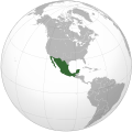
Bestand:Second Mexican Empire (orthographic projection).svg

Afbeelding in hogere resolutie (SVG-bestand, nominaal 541 × 541 pixels, bestandsgrootte: 424 kB)
Dit bestand is afkomstig van Wikimedia Commons en kan ook in andere projecten gebruikt worden. De bestandsbeschrijvingspagina wordt hieronder weergegeven.
Beschrijving
| BeschrijvingSecond Mexican Empire (orthographic projection).svg |
English: Second Mexican Empire (orthographic projection)
Español: Segundo Imperio Mexicano (proyección ortográfica) |
||
| SVG ontwikkeling InfoField | |||
| Datum | |||
| Bron | Eigen werk | ||
| Auteur | Heraldry | ||
| Andere versies |
العربية: الرجاء، قراءة الميثاق.
বাংলা: দয়া করে, রীতিনীতিটি পড়ুন।
Deutsch: Bitte lies die Konventionen.
English: Please, read the conventions.
Español: Por favor, lea las convenciones.
Filipino: Paki-basa ang mga kumbensyon.
Français : S'il vous plaît, lisez les conventions.
हिन्दी: कृपया सभागमों को पढ़ लें.
Bahasa Indonesia: Silakan, baca konvensi.
Italiano: Si prega di leggere le convenzioni.
日本語: 規約をご確認ください。
ქართული: გთხოვთ, გაეცნოთ კონვენციებს.
Македонски: Ве молиме, прочитајте ги општоприфатените правила.
Português: Por favor, leia as convenções.
Русский: Пожалуйста, прочитайте соглашения.
Tagalog: Paki-basa ang mga kumbensyon.
Українська: Будь ласка, прочитайте конвенції.
Tiếng Việt: Hãy đọc công văn trước khi đăng.
中文(繁體):請檢視常規
中文(简体):请查看常规
Orthographic projections maps created by Heraldry:
|
Licentie
The map has been created with the Generic Mapping Tools: https://www.generic-mapping-tools.org/ using one or more of these public-domain datasets for the relief:
বাংলা ∙ English ∙ español ∙ français ∙ italiano ∙ 日本語 ∙ македонски ∙ sicilianu ∙ 中文(简体) ∙ 中文(繁體) ∙ +/− |

|
Toestemming wordt verleend voor het kopiëren, verspreiden en/of wijzigen van dit document onder de voorwaarden van de GNU-licentie voor vrije documentatie, versie 1.2 of enige latere versie als gepubliceerd door de Free Software Foundation; zonder Invariant Sections, zonder Front-Cover Texts, en zonder Back-Cover Texts. Een kopie van de licentie is opgenomen in de sectie GNU-licentie voor vrije documentatie.http://www.gnu.org/copyleft/fdl.htmlGFDLGNU Free Documentation Licensetruetrue |
| Dit bestand is gelicenseerd onder de Creative Commons-licentie Naamsvermelding-Gelijk delen 3.0 Unported | ||
| ||
| Deze licentietag is toegevoegd aan dit bestand in verband met de GFDL licentie-update.http://creativecommons.org/licenses/by-sa/3.0/CC BY-SA 3.0Creative Commons Attribution-Share Alike 3.0truetrue |
Bijschriften
Items getoond in dit bestand
beeldt af
Waarde zonder Wikidata-item
Bestandsgeschiedenis
Klik op een datum/tijd om het bestand te zien zoals het destijds was.
| Datum/tijd | Miniatuur | Afmetingen | Gebruiker | Opmerking | |
|---|---|---|---|---|---|
| huidige versie | 6 sep 2014 15:44 |  | 541 × 541 (424 kB) | Elevatorrailfan | Adding new borders to show that the Confederate States of America was an Unrecognized state. |
Bestandsgebruik
Dit bestand wordt op de volgende 2 pagina's gebruikt:
Metadata
Dit bestand bevat aanvullende gegevens, die waarschijnlijk door een fotocamera, scanner of fotobewerkingsprogramma toegevoegd zijn.
Als het bestand is aangepast, komen sommige details mogelijk niet overeen met het gewijzigde bestand.
| Breedte | 541.47876 |
|---|---|
| Hoogte | 541.47876 |


