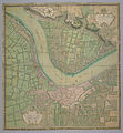
Bestand:Plan de Bordeaux et de ses environs, par Hippolyte Matis.jpg
Naar navigatie springen
Naar zoeken springen


Grootte van deze voorvertoning: 555 × 599 pixels. Andere resoluties: 222 × 240 pixels | 445 × 480 pixels | 556 × 600 pixels | 711 × 768 pixels | 948 × 1.024 pixels | 3.705 × 4.000 pixels.
Afbeelding in hogere resolutie (3.705 × 4.000 pixels, bestandsgrootte: 4,03 MB, MIME-type: image/jpeg)
Bestandsgeschiedenis
Klik op een datum/tijd om het bestand te zien zoals het destijds was.
| Datum/tijd | Miniatuur | Afmetingen | Gebruiker | Opmerking | |
|---|---|---|---|---|---|
| huidige versie | 26 apr 2007 05:00 |  | 3.705 × 4.000 (4,03 MB) | Petrusbarbygere | {{Information |Description=Plan de Bordeaux et de ses environs, par Hippolyte Matis, (1716-1717). |Source=http://www.cg78.fr/archives/img/db/seriea/hd/sa00022.jpg |Date=1716-1717 |Author=Hippolyte Matis }} Category:Bordeaux [[Category:Old maps of Fra |
Bestandsgebruik
Dit bestand wordt op de volgende pagina gebruikt: