Bestand:Locator Westphalian Circle.svg
Naar navigatie springen
Naar zoeken springen


Afmetingen van deze voorvertoning van het type PNG van dit SVG-bestand: 613 × 600 pixels Andere resoluties: 245 × 240 pixels | 491 × 480 pixels | 785 × 768 pixels | 1.046 × 1.024 pixels | 1.165 × 1.140 pixels.
Afbeelding in hogere resolutie (SVG-bestand, nominaal 1.165 × 1.140 pixels, bestandsgrootte: 193 kB)
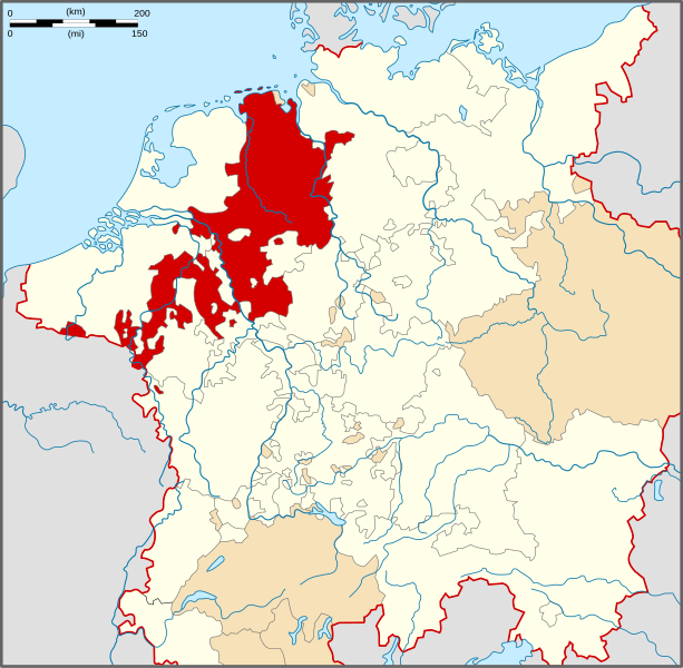
| Beschrijving | Locator Map of the Lower Rhenish-Westphalian Circle of Holy Roman Empire during the mid 16th century (the situation shown is that after the Burgundian treaty 1548 following which the bishopric of Utrecht passed to the Burgundian Circle). |
| Datum | |
| Bron | PERTHES ATLAS Geschichte |
| Auteur | Sir Iain |
| Toestemming (Hergebruik van dit bestand) |
Attribution ShareAlike 3.0 |
Dit bestand is gelicenseerd onder de Creative Commons-licentie Naamsvermelding-Gelijk delen 3.0 Unported
- De gebruiker mag:
- Delen – het werk kopiëren, verspreiden en doorgeven
- Remixen – afgeleide werken maken
- Onder de volgende voorwaarden:
- naamsvermelding – U moet op een gepaste manier aan naamsvermelding doen, een link naar de licentie geven, en aangeven of er wijzigingen in het werk zijn aangebracht. U mag dit op elke redelijke manier doen, maar niet zodanig dat de indruk wordt gewekt dat de licentiegever instemt met uw werk of uw gebruik van zijn werk.
- Gelijk delen – Als u het materiaal remixt, transformeert of erop voortbouwt, moet u uw bijdragen verspreiden onder dezelfde licentie als die van het origineel, of een licentie die daarmee verenigbaar is.
Bestandsgeschiedenis
Klik op een datum/tijd om het bestand te zien zoals het destijds was.
| Datum/tijd | Miniatuur | Afmetingen | Gebruiker | Opmerking | |
|---|---|---|---|---|---|
| huidige versie | 28 mrt 2010 17:20 | | 1.165 × 1.140 (193 kB) | Sir Iain | {{Information |Description=Locator Map of the Westphalian Circle of Holy Roman Empire. |Source=PERTHES ATLAS Geschichte |Date=28/03/2010 |Author=Sir Iain |Permission=Attribution ShareAlike 3.0 |other_versions= }} {{cc-by-sa-3.0}} [[Category:Reichskreise |
Bestandsgebruik
Dit bestand wordt op de volgende 2 pagina's gebruikt: