Bestand:Lizars Mexico & Guatimala 1831 UTA.jpg
Naar navigatie springen
Naar zoeken springen

Grootte van deze voorvertoning: 708 × 600 pixels. Andere resoluties: 283 × 240 pixels | 567 × 480 pixels | 907 × 768 pixels | 1.209 × 1.024 pixels | 6.185 × 5.238 pixels.
Afbeelding in hogere resolutie (6.185 × 5.238 pixels, bestandsgrootte: 11,59 MB, MIME-type: image/jpeg)
Beschrijving
| Titel |
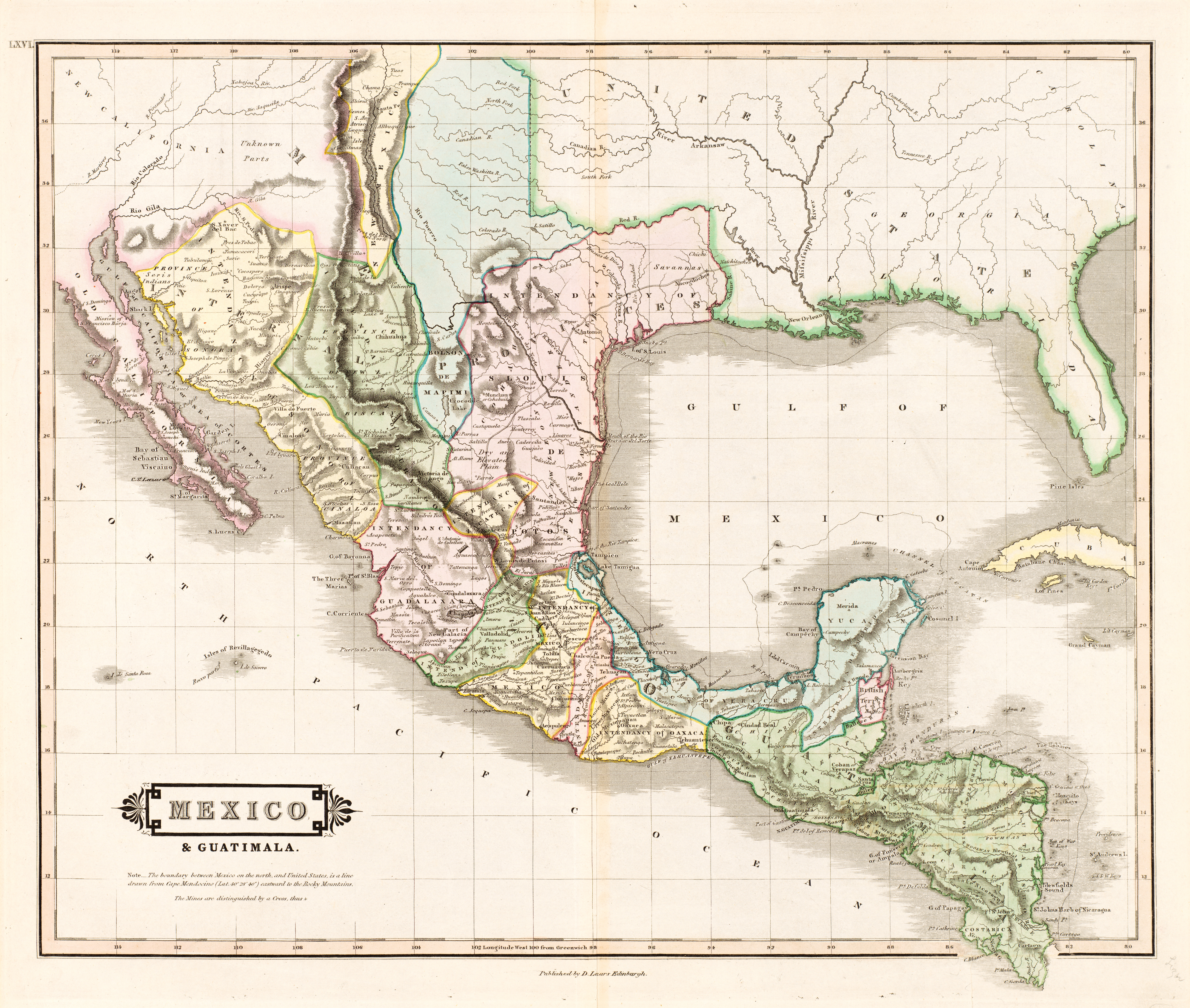
English: Mexico & Guatimala [sic] |
||||||||||||||||||||||||||
| Beschrijving |
English: The creator of this map was probably Daniel Lizars II (1793-1875), the son of Edinburgh map engraver and publisher Daniel Lizars I (1754-1812) and younger brother of William Home Lizars (1788-1859). Shortly after producing the map, Daniel II went bankrupt in 1832 and emigrated to Canada in 1833. Lizars' map shows Mexico's administrative districts as Intendencies (Intendencias) and Internal Provinces (Provincias Internas) dating from the Spanish era. His depiction of the area that became Texas is notably jarring to modern viewers because his map further exaggerated some of the cartographic errors of his predecessors and contemporaries: particularly, a southerly "dip" of the middle Red River and the southerly courses of the Trinity, Brazos, and Colorado Rivers (which actually flow southeasterly). Settlements shown include Nacogdoches, "St." Antonio, and "Loredo". Interestingly, Lizars included the "British Territory" that became British Honduras or Belize. British logging settlements existed in the territory by the late eighteenth century and, although the British government had been hesitant to create a colony for fear of provoking the Spanish, settlers there were largely self-governing. |
||||||||||||||||||||||||||
| Datum | ca. 1831 | ||||||||||||||||||||||||||
| Bron | UTA Libraries Cartographic Connections: kaart / tekst | ||||||||||||||||||||||||||
| Maker |
|
||||||||||||||||||||||||||
| Naamsvermeldingen |
English: The University of Texas at Arlington Libraries Special Collections, Gift of Virginia Garrett |
||||||||||||||||||||||||||
| Geotemporal data | |||||||||||||||||||||||||||
| Map location |
Mexico Guatemala Texas |
||||||||||||||||||||||||||
| Georeferencing | If inappropriate please set warp_status = skip to hide. | ||||||||||||||||||||||||||
| Bibliographic data | |||||||||||||||||||||||||||
| Publicatie |
The Edinburgh Geographical and Historical Atlas |
||||||||||||||||||||||||||
| Auteur |
John Hamilton |
||||||||||||||||||||||||||
| Plaats van uitgave |
Edinburgh Londen Dublin |
||||||||||||||||||||||||||
| Uitgever |
John Hamilton Whittaker, Treacher & Co. W. Curry, Jun. & Co. |
||||||||||||||||||||||||||
| Archival data | |||||||||||||||||||||||||||
| Collectie |
|
||||||||||||||||||||||||||
| Afmetingen | hoogte: 42 cm; breedte: 51,5 cm | ||||||||||||||||||||||||||
| Techniek | colored gravure op papier | ||||||||||||||||||||||||||
| artwork-references |
Worms, Laurence; Ashley Baynton-Williams (2011) British Map Engravers, Londen: Rare Book Society, pp. 406–409 |
||||||||||||||||||||||||||
| Andere versies | |||||||||||||||||||||||||||
.jpg)
Licentie

|
This file was provided to Wikimedia Commons by the University of Texas at Arlington Libraries as part of a cooperation project. The University of Texas at Arlington Libraries is part of the University of Texas at Arlington, a public research university located in Arlington, Texas.
|
|
De auteur overleed in 1875, dus dit werk bevindt zich in het publiek domein in landen en gebieden waar de auteursrechttermijn het leven van de auteur plus 100 jaar of minder is. Dit werk bevindt zich in het publiek domein in de Verenigde Staten omdat het gepubliceerd werd (of geregistreerd bij de U.S. Copyright Office) voor 1 januari 1930. | |
| Van dit bestand is vastgesteld dat er geen bekende auteursrechtaanspraken op rusten, alle aanverwante en naburige rechten daarbij inbegrepen. | |
Bestandsgeschiedenis
Klik op een datum/tijd om het bestand te zien zoals het destijds was.
| Datum/tijd | Miniatuur | Afmetingen | Gebruiker | Opmerking | |
|---|---|---|---|---|---|
| huidige versie | 13 jul 2019 14:26 | | 6.185 × 5.238 (11,59 MB) | Michael Barera | == {{int:filedesc}} == {{Map |title = ''Mexico & Guatimala'' [sic] |description = {{en|The creator of this map was probably Daniel Lizars II (1793-1875), the son of Edinburgh map engraver and publisher Daniel Lizars I (1754-1812) and younger brother of William Home Lizars (1788-1859). Shortly after producing the map, Daniel II went bankrupt in 1832 and emigrated to Canada in 1833. Lizars' map shows Mexico's administrative districts as Intendencies (''Intendencias'') and In... |
Bestandsgebruik
Geen enkele pagina gebruikt dit bestand.