Bestand:1918 British Government Map illustrating Territorial Negotiations between H.M.G. and King Hussein.png
Naar navigatie springen
Naar zoeken springen
Geen hogere resolutie beschikbaar.
1918_British_Government_Map_illustrating_Territorial_Negotiations_between_H.M.G._and_King_Hussein.png (508 × 546 pixels, bestandsgrootte: 489 kB, MIME-type: image/png)
Beschrijving
| Beschrijving |
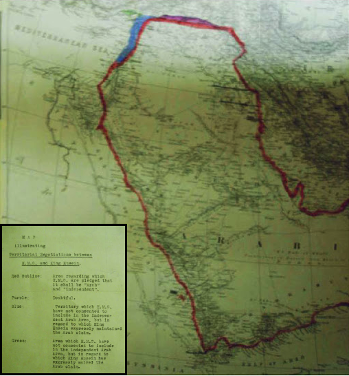
العربية: خريطة تعود لعام 1918 توضح الحدود الإقليمية للاراضي التي طالب بها الشريف الحسين أثناء المراسلات مع مكماهون
English: MPK 1/410 extracted from FO 371/4368; (7) Larger printed map, showing additionally the whole Arabian peninsula. Reference table. Scale: 1:6,969,600. Ms additions, coloured, mark several areas under discussion. Title affixed: 'Map illustrating Territorial Negotiations between H.M.G. amd King Hussein'; reference table to additions affixed. |
| Datum | |
| Bron | National Archives: http://discovery.nationalarchives.gov.uk/details/r/C3980431 |
| Auteur | UK Government |
Licentie
Note: This map is not in copyright, since UK Crown Copyright for such materials expires 50 years after publication.
Dit artistieke werk gecreëerd door de Britse regering bevindt zich in het publiek domein.
Dit is vanwege een van de volgende redenen:
HMSO heeft verklaard dat het vervallen van Crown Copyrights wereldwijd van toepassing is (ref: HMSO Email Reply)
|
 |
Bestandsgeschiedenis
Klik op een datum/tijd om het bestand te zien zoals het destijds was.
| Datum/tijd | Miniatuur | Afmetingen | Gebruiker | Opmerking | |
|---|---|---|---|---|---|
| huidige versie | 8 nov 2016 22:54 | | 508 × 546 (489 kB) | Onceinawhile | User created page with UploadWizard |
Bestandsgebruik
Dit bestand wordt op de volgende pagina gebruikt: