Bestand:1850 Mitchell Map of Holland and Belgium - Geographicus - HollandBelgium-mitchell-1850.jpg
Naar navigatie springen
Naar zoeken springen

Grootte van deze voorvertoning: 499 × 600 pixels. Andere resoluties: 200 × 240 pixels | 399 × 480 pixels | 639 × 768 pixels | 852 × 1.024 pixels | 2.496 × 3.000 pixels.
Afbeelding in hogere resolutie (2.496 × 3.000 pixels, bestandsgrootte: 2,21 MB, MIME-type: image/jpeg)
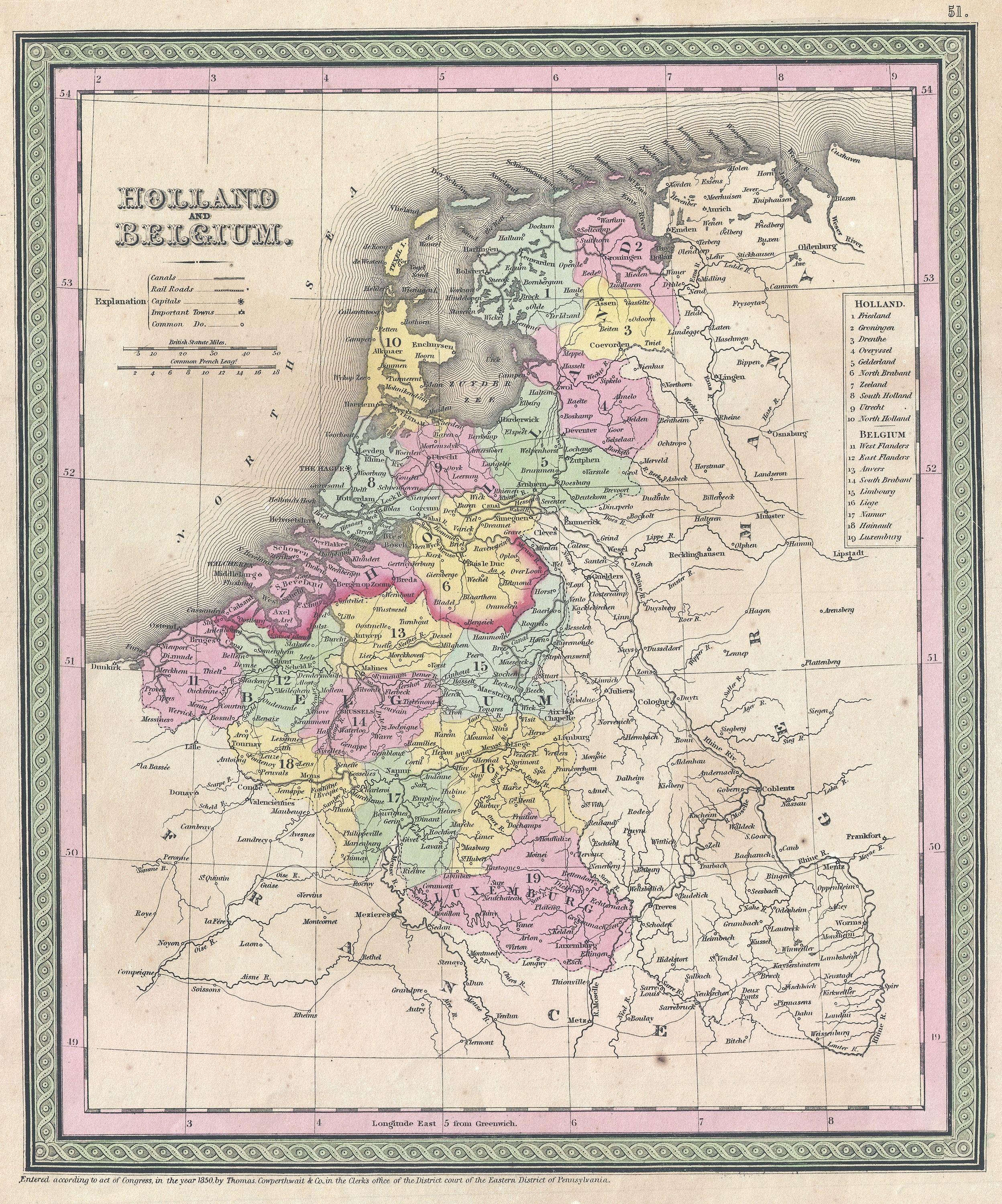
| Samuel Augustus Mitchell: Holland and Belgium.
( |
||||||||||||||||||||
|---|---|---|---|---|---|---|---|---|---|---|---|---|---|---|---|---|---|---|---|---|
| Kunstenaar |
|
|||||||||||||||||||
| Titel |
Holland and Belgium. |
|||||||||||||||||||
| Beschrijving |
English: An attractive example of S. A. Mitchell Sr.’s 1850 map of Holland and Belgium. Depicts both countries color coded according to individual departments. Includes Luxembourg. Surrounded by the green border common to Mitchell maps from the 1850s. Prepared by S. A. Mitchell for issued as plate no. 51 in the 1850 edition of his New Universal Atlas . Dated and copyrighted, “Entered according to act of Congress, in the year 1850, by Thomas Cowperthwait & Co., in the Clerks office of the District court of the Eastern District of Pennsylvania. |
|||||||||||||||||||
| Datum | 1850 (dated) | |||||||||||||||||||
| Afmetingen | hoogte: 13 in (33 cm); breedte: 11 in (27,9 cm) | |||||||||||||||||||
| Inventarisnummer |
Geographicus link: HollandBelgium-mitchell-1850 |
|||||||||||||||||||
| Bron/fotograaf |
Mitchell Sr., S. A.,A New Universal Atlas Containing Maps of the various Empires, Kingdoms, States and Republics Of The World. (1850 issue)
|
|||||||||||||||||||
| Toestemming (Hergebruik van dit bestand) |
|
|||||||||||||||||||
Bestandsgeschiedenis
Klik op een datum/tijd om het bestand te zien zoals het destijds was.
| Datum/tijd | Miniatuur | Afmetingen | Gebruiker | Opmerking | |
|---|---|---|---|---|---|
| huidige versie | 23 mrt 2011 02:24 | | 2.496 × 3.000 (2,21 MB) | BotMultichillT | {{subst:User:Multichill/Geographicus |link=http://www.geographicus.com/P/AntiqueMap/HollandBelgium-mitchell-1850 |product_name=1850 Mitchell Map of Holland and Belgium |map_title=Holland and Belgium. |description=An attractive example of S. A. Mitchell Sr |
Bestandsgebruik
Dit bestand wordt op de volgende pagina gebruikt: